![Map of today's active volcanoes]()
Map of today's active volcanoes
) The eruption continues without any significant change in the activity since the last update.
Wed, 24 Apr 2024, 14:00
JMA reported that eruptive activity at Suwanosejima's Ontake Crater continued during 15-22 April. Crater incandescence was observed in webcam images nightly. No explosions were detected but ashfall was reported in Toshima village (3.5 km SSW); dates were not specified.
Wed, 24 Apr 2024, 14:00INGV reported that eruptive activity continued at Stromboli during 15-21 April. Webcam images showed Strombolian activity at two vents in Area N (one at N1 and one at N2), within the upper part of the Sciara del Fuoco, and from three vents at S2 in Area C-S (South-Central Crater) in the crater terrace. Weather conditions and technical difficulties sometimes prevented observations.
Wed, 24 Apr 2024, 14:00
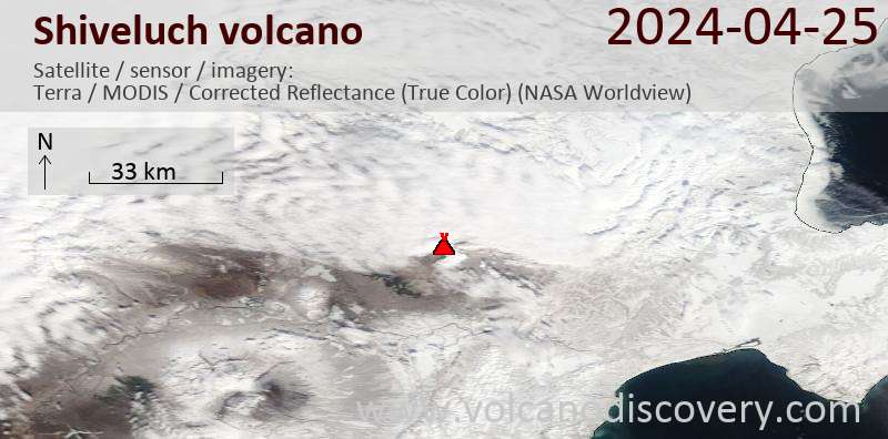
KVERT reported that eruptive activity at Sheveluch continued during 11-18 April with a daily thermal anomaly identified in satellite images. The Aviation Color Code remained at Orange (the third level on a four-color scale). Dates are based on UTC times; specific events are in local time where noted.
Read all
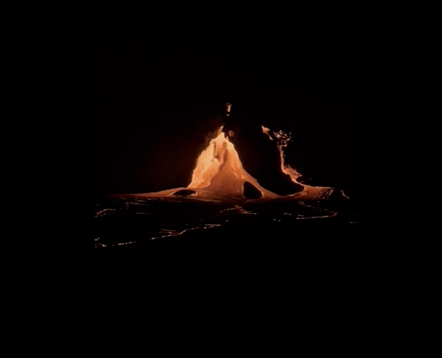
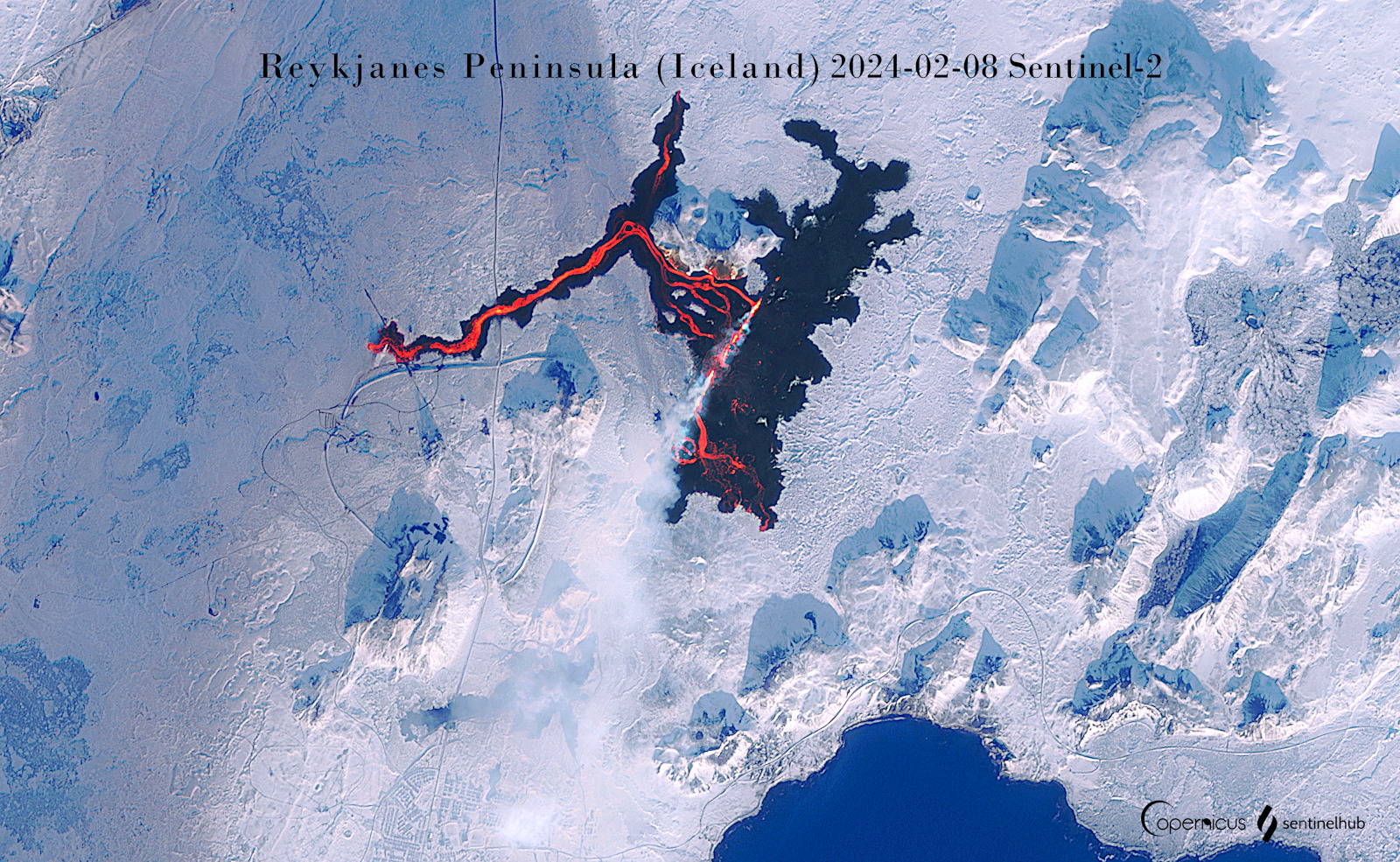
Wed, 24 Apr 2024, 14:00IMO reported that the cone just E of Sundhnúk and along the fissure within the Reykanes volcanic system continued to erupt lava during 15-23 April. Gas emissions continued to drift downwind and residents were advised to monitor air quality. Lava flowed a short distance from the crater mostly S and the flows thickened near the crater.
Read all
Wed, 24 Apr 2024, 14:00
CENAPRED reported that eruptive activity continued at Popocatépetl during 16-23 April. The seismic network recorded long-period events totaling 43-171 per day that were sometimes accompanies by steam-and-gas emissions. The seismic network also recorded 5-14 minutes of tremor each day during 16-19 April and a few volcano-tectonic earthquakes.
Read all
Wed, 24 Apr 2024, 14:00BPPTKG reported that the eruption at Merapi (on Java) continued during 12-18 April. Seismicity remained at high levels. The SW lava dome produced 111 lava avalanches that traveled as far as 1.7 km down the SW flank.
Read all
Wed, 24 Apr 2024, 14:00
PVMBG reported that eruptive activity at Marapi (on Sumatra) was ongoing during 17-22 April. White-and-gray ash plumes rose 250-300 m above the summit and drifted SE and W on 21 April. White steam-and-gas plumes rose 250-300 m above the summit and drifted in multiple directions on 17, 19, and 22 April.
Read all
Wed, 24 Apr 2024, 14:00PVMBG reported that the eruption at Lewotolok continued during 17-23 April. White-and-gray ash plumes rose 100-600 m above the summit and drifted SE, W, and NW almost every day; white emissions rose 300-500 m above the summit and drifted W and NW during 19-20 April. The Alert Level remained at 3 (on a scale of 1-4) and the residents of Lamawolo, Lamatokan, and Jontona were warned to stay 2 km away from the vent and 3 km away from the vent on the S and SE flanks.
Read all
Wed, 24 Apr 2024, 14:00
PVMBG reported that during 17-18 and 20-22 April white steam-and-gas plumes rose as high as 100 m above the summit of Lewotobi's Laki-laki volcano and drifted N, NE, and E. On 23 April a white-and-gray ash plume rose 100-200 m and drifted SW and W. The Alert Level remained at 2 (the second lowest level on a scale of 1-4) and the public was warned to stay outside of the exclusion zone, defined as a 2-km radius around Laki-laki crater, 3 km to the NNE, and 5 km on the NE flanks.
Read all
Wed, 24 Apr 2024, 14:00Satellite data showed an area of yellowish-green discolored water that was about 5 km long in the N-S direction and about 3 km in the E-W direction, in the vicinity of the submarine Lateiki volcano on 21 April. A more diffuse plume of discolored water extended another ~12 km WNW before dissipating.
Read all
Wed, 24 Apr 2024, 14:00
On 19 April PVMBG lowered the Alert Level for Krakatau to 2 (on a scale of 1-4) based on visual observations and instrumental data. The public was warned to stay at least 2 km away from the crater.
Read all
Wed, 24 Apr 2024, 14:00Satellite data showed an area of yellow-green discolored water that was about 4.2 km in diameter in the vicinity of the submarine Kavachi volcano on 19 April. A more diffuse plume of discolored water extended another ~11 km NE before dissipating.
Read all